At the top of the Earth, the Arctic Ocean’s sea ice cap expands and contracts with the seasons, typically reaching its largest annual extent in March. In 2026, this peak occurred on March 15 and reached an area of 14.29 million square kilometers, coinciding with the lowest maximum observed since satellite monitoring began in 1979. One of the key areas contributing to this year’s low maximum was the Barents Sea.
The Barents Sea is located on the rim of the Arctic Ocean, bordering Norway’s Svalbard archipelago to the northwest, and Russia’s Franz Josef Land and Novaya Zemlya islands to the northeast and east, respectively. This is one of more than a dozen subregions, including the central Arctic Ocean and nearby oceans, bays, and waterways, where scientists are using remote sensing to track sea ice. The area is important for fishing, shipping routes, and scientific research.
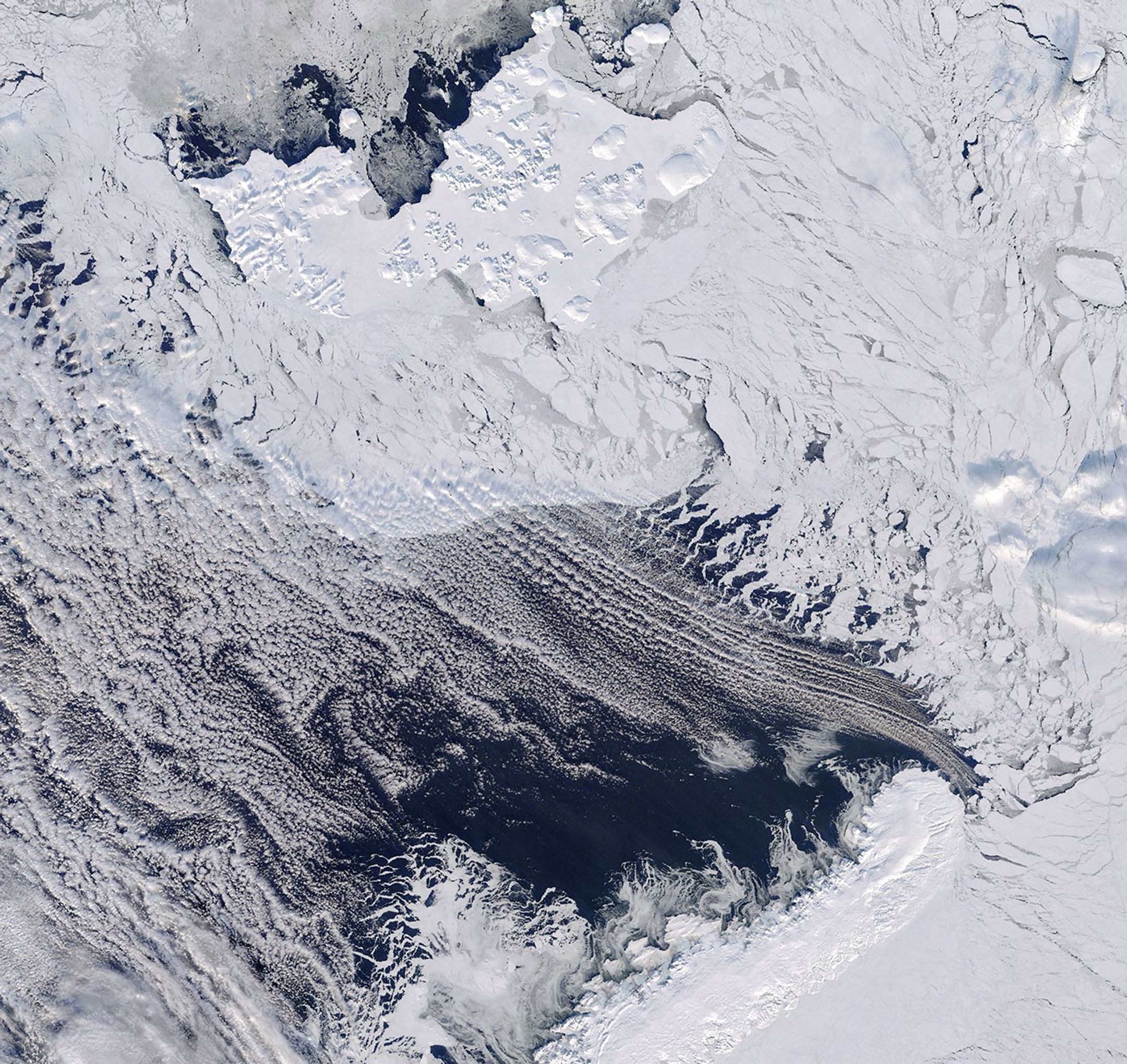
On March 17, 2026, the Terra satellite captured this image of the northern Barents Sea. Near Franz Josef Land, broken sea ice drifted into the open ocean near Novaya Zemlya. As was the case that day, the region is often cloudy, but most of the clouds were thin enough to see the sea ice and water below.
In addition to the small extent, data from NASA’s ICESat-2 satellite shows that the Barents Sea ice was also very thin in mid-March 2026, said Nathan Kurtz, director of the Cryosphere Science Laboratory at NASA Goddard Space Flight Center.
Past years, such as 2021 and 2025, have also seen particularly thin ice around the time of maximum. “But what was striking this year was that in addition to the thinner areas to the north, even more areas of the Barents Sea were completely melted,” Kurz said.
On the other side of the Arctic, the Sea of Okhotsk also contributed to the decrease in Arctic-wide sea ice extent in March 2026. However, the factors driving the losses are different in the two regions.
In the Barents region, studies have shown that the main culprit is large-scale atmospheric circulation, with warm, moist air from the North Atlantic flowing directly into the region via winds, accelerating melting. These winds can be influenced by tropical climates thousands of miles away. The disturbance, which occurred on the maritime continent near Indonesia, “sends ripples in the atmosphere that could reach the North Pole within a week or two,” Kurz said.
In contrast, most of the Sea of Okhotsk is seasonal thin ice, the thickness of which varies from year to year. Local winds play a big role, sometimes pushing ice and creating thick, raised areas, and sometimes spreading it and thinning it. Therefore, ice loss there is mainly driven by local weather, unlike in the Barents Sea, where distant atmospheric forces have a greater influence.
NASA Earth Observatory image by Michala Garrison using NASA MODIS data. ios dislance and GIBS/Worldview. Kathryn Hansen’s story.
- NASA (March 26, 2026) Arctic winter sea ice is at record low, NASA, NSIDC scientists find. Accessed April 2, 2026.
- National Snow and Ice Data Center (2026) MASIE-NH Daily Image Viewer. Accessed April 2, 2026.
- National Snow and Ice Data Center (March 25, 2026) Arctic sea ice reaches its maximum level again. Accessed April 2, 2026.
- Futahashi S. Others. (2018) Estimation of sea ice thickness and volume in the Sea of Okhotsk based on ICESat data. glaciological chronicle59 (76pt2), 101-111
- NOAA (2025) Regional Sea Ice. Accessed April 2, 2026.
- Yu Feng Xu, P. Others. (2023) Physical links from atmospheric circulation patterns to Barents-Kara sea ice variations from synoptic to seasonal timescales during the cold season. climate journal36, 8027–8040.
- Zheng, C. Others. (2022) Turbulent heat fluxes, downward longwave radiation, and large-scale atmospheric circulation associated with extreme winter sea ice loss events in the Barents and Kara seas. climate journal, 35, 3747–3765.
#Barents #Sea #tied #Arctic #sea #ice #NASA #Science